


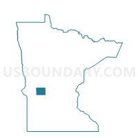
Brooten Voting District, Pope County, Minnesota
About
Outline

Summary
| Unique Area Identifier | 603748 |
| Name | Brooten Voting District |
| County | Pope County |
| State | Minnesota |
| Area (square miles) | 0.01 |
| Land Area (square miles) | 0.01 |
| Water Area (square miles) | 0.00 |
| % of Land Area | 100.00 |
| % of Water Area | 0.00 |
| Latitude of the Internal Point | 45.50921030 |
| Longtitude of the Internal Point | -95.13268200 |
Maps

Graphs
Select a template below for downloading or customizing gragh for Brooten Voting District, Pope County, Minnesota


Neighbors
Neighoring Voting District (by Name) Neighboring Voting District on the Map
- Bangor Twp. Voting District, Pope County, MN
- Brooten Voting District, Stearns County, MN
- North Fork Twp. Voting District, Stearns County, MN
Top 10 Neighboring County Subdivision (by Population) Neighboring County Subdivision on the Map
- Brooten city, Stearns County, MN (743)
- North Fork township, Stearns County, MN (247)
- Bangor township, Pope County, MN (185)
- Brooten city, Pope County, MN (0)